GeoData International (English) 9.00
Software for world-wide towns, municipalities and postal codes
Software for world-wide towns, municipalities and postal codes
Software Specs
Publisher:............ Killet Softwareentwicklung GbR
License:............... Demo
Price:................... $600.00
File size:.............. 2048 MB
Downloads:.........
Release date:...... 01 Mar 2015
Last update:........ 27 Feb 2017
Publisher review for GeoData International (English) 9.00:
Review by: Killet Softwareentwicklung GbR
Geodata International is a world-wide database of countries with georeferenced towns, municipalities, postal codes and administrative units with WGS84 and UTM coordinates and elevations for geocoding, proximity search, navigation, distance calculation.
The georeference can be used to show a customer the nearest chain store by doing a proximity search. On the basis of the georeferences business zones, statistics or general maps can be made. Towns, municipalities and postal codes can be assigned to the superordinated administrative units and the distances between places or postal areas can be determined with the coordinates contained in the database tables. For that the georeferences are available in all country database tables as UTM coordinates on the natural and an uniformly meridian strip and as geographical coordinates in degree and deg/min/sec notation.
The database tables are present in the file format CSV (Comma Separated Values). The character set used is UTF8.
Requirements:
Operating system:
Windows All
 9.00")
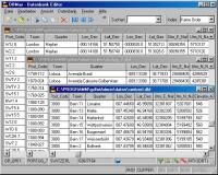
GeoData International (English) screenshots:
GeoData International (English) download tags:
Copyright information:
Based on 0 ratings. 0 user reviews.